Nagano Winter Forecast | Japan El Niño 2027
Japan El Niño 2026/27 Winter
First, a little bit of explanation of how we come to the following conclusions. We usually rely on a variety of sources – both formal (JMA, NOAA and other weather bodies) and informal (resort locals and knowledgeable pundits), as well as a personal experience of the region over 30 years. Working with all these there tends to be a diversity of opinion but we do our best to collate it all into something intelligible.
For this report however I have leaned heavily into official forecasts as there has been A LOT of different forecasts from different areas of the internet. I am largely discounting those as they vary from a great winter to an absolute disaster.
Secondly, as much as we might not like (or many try to deny it), the effects of climate change are becoming clearer. And that means that traditional weather models are not as reliable anymore. Unfortunately, an El Niño event seems to be very much likely this winter.
Lastly, this is largely one official perspective on the upcoming winter weather. So please take it as general advice only and don’t do all your bookings based upon it.
TLDR (key notes)
- The influence of cold air masses that come from Siberia across the Sea of Japan will be somewhat minimized.
- Winter precipitation is likely to be higher due to the influence of low-pressure systems. Note this could mean ‘more snow’ or ‘more rain’. Of course, hoping the former.
- Because the impact of cold air will be minimal, winter temperatures will be higher and snowfall will be lighter (particularly closer to the Japan Sea).
Further reading: Nagano Snow Report and Weather Conditions | Nagano Webcams
Nagano Winter Forecast: More about Japan El Niño 2026/27 Winter
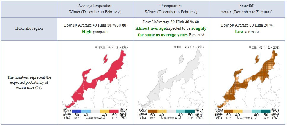
A recent climate forecast (September 2026 – see below) suggests a transition toward a strong El Niño event in 2026 and early 2027, which could have meaningful impacts on winter weather patterns across Japan. El Niño refers to a warming of sea surface temperatures in the central and eastern tropical Pacific, and it tends to alter atmospheric circulation on a global scale. For Japan, one of the most important consequences is how it affects winter snowfall.
Under El Niño conditions, the Siberian High weakens, and with it the East Asian winter monsoon—the cold, dry northwesterly winds that normally sweep across the Sea of Japan. These winds are crucial for producing Japan’s famous heavy snowfall, especially along the western side of the country. As cold air passes over the relatively warm Sea of Japan, it picks up moisture and deposits it as snow when it reaches land. When this flow is weaker, snowfall tends to decrease.
As a result, regions along the Sea of Japan coast—such as Niigata, Hokuriku, and parts of western Hokkaido—typically experience below-average snowfall during strong El Niño winters. Snow seasons in these areas may start later, be less consistent, and lack the prolonged heavy snow events seen in colder years. Mountain regions still receive snow due to elevation, but overall totals are often reduced and more variable.
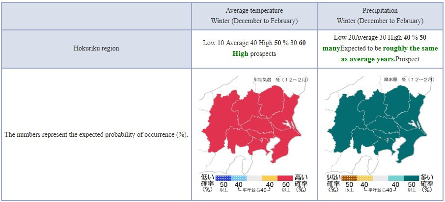
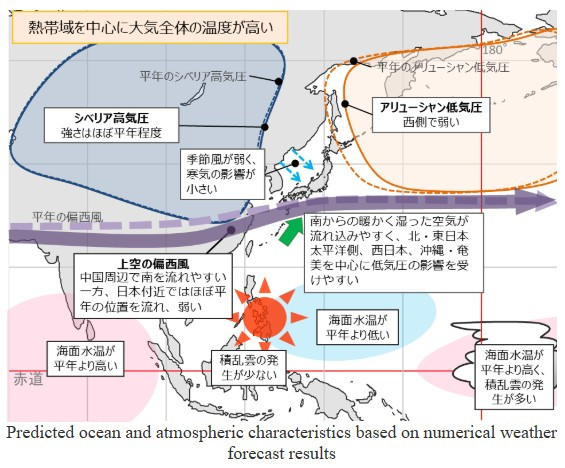
Niigata & Nagano Winter Forecast: The basic outlook
- The El Niño phenomenon is expected to continue into winter. Sea surface temperatures will be high in the eastern and central equatorial Pacific, and cumulonimbus clouds will be more prevalent in these areas. On the other hand, cumulonimbus cloud formation will be less frequent near the Philippines.
- Therefore, the upper-air westerlies will tend to flow south around China, while flowing near Japan at roughly their normal position and remaining weak. The Siberian high-pressure system will be roughly normal in strength, but the Aleutian low-pressure system will be weak on its western side, resulting in weak monsoon winds near Japan.
- Due to global warming and the El Niño phenomenon, the overall atmospheric temperature will likely be higher than usual, especially in tropical regions.
- Due to these factors, the impact of the cold air mass will be minimal in the vicinity of Japan.
- Because high pressure is likely to form near the Philippines, warm, humid air from the south is likely to flow into the vicinity of Japan, making the Pacific coast of northern and eastern Japan, western Japan, and Okinawa and Amami particularly susceptible to the effects of low pressure systems.
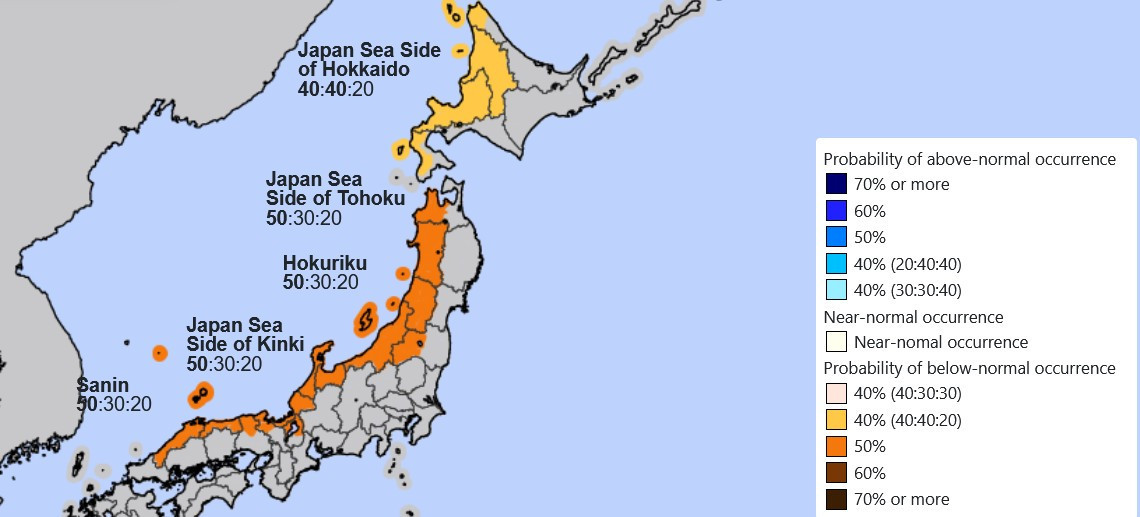
Nagano Winter Forecast: More information
As a comparison, up north in Hokkaido, particularly inland and eastern areas, tends to be somewhat less affected because temperatures remain cold enough to support snowfall. However, even there, slight reductions and more mixed precipitation near coastal areas can occur.
It’s important to note that these are general trends rather than guarantees. In recent years (20-21 & 23-24) El Niño / Positive dipole mode has brought warm(ish) winters with under-average and uneven falls. However, short-term weather systems can still bring heavy snowfall, even in El Niño years. However, the overall pattern points toward a milder winter with reduced snowfall across much of Japan, especially in its traditionally snow-heavy regions.
In summary, if the forecasted El Niño develops as expected, Japan is likely to see a 26/27 winter with less snow, warmer temperatures, and fewer sustained cold outbreaks, contrasting with the deeper, more persistent snowpack typical of La Niña conditions.
FYI Seasonal forecasts can be found on the JMA (Japan Meteorology Agency) site, and these will be updated later in the year.
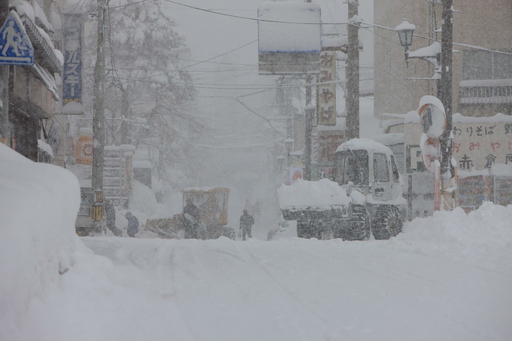
The war on snow in Akakura Onsen.
Observations of recent winters in Nagano during El Niño Japan
Historical strong El Niño events provide a useful guide to what Japan might experience if the current forecast develops as expected. Two of the clearest examples—1997–98 and 2015–16—show a consistent pattern of milder winters and reduced snowfall across much of the country.
During both events, warming in the tropical Pacific weakened the East Asian winter monsoon, which normally drives cold air from Siberia across the Sea of Japan. This process is essential for producing the Japan Sea’s heavy coastal snowfall. With weaker cold-air outbreaks, the snow machine is less efficient, leading to lower overall snowfall totals, especially along the Sea of Japan side in regions like Niigata and Hokuriku.
In the 1997–98 El Niño, one of the strongest on record, Japan experienced a notably warm and low-snow winter, with shorter snow seasons and more frequent rain events. The 2015–16 event showed a similar pattern: snowfall was generally below average and less consistent, with snow arriving in bursts rather than through prolonged periods of accumulation.
Across both winters, a few key themes stand out. Snowfall was not absent, particularly in mountain regions and northern areas like Hokkaido, but it was less persistent and more variable. Warmer temperatures also meant that precipitation more often fell as rain or mixed precipitation, especially in lower elevations and coastal areas.
Comparing these historical patterns to the current forecast—which indicates a potentially strong El Niño—suggests a similar outcome. Japan is likely to see a warmer winter with reduced and less reliable snowfall, particularly in its traditionally snow-heavy regions. While occasional heavy snowstorms remain possible, the overall season would likely resemble past El Niño winters: patchier snow cover, fewer sustained cold outbreaks, and below-average totals overall.

Japan El Niño, Japan El Nino, Nagano Winter Forecast
Disclaimer
This is a resort-by-resort summary of the probabilities & risks for the 2026-27 Nagano ski season, has been calculated by using available ensemble forecasts, climatological data, and historical El Niño / ENSO-neutral behaviour. Because detailed model ensembles by individual resort are not yet widely published, these are estimates (+/−) rather than firm probabilities.
Short, practical advice for planning
- If you want more reliable powder days, favor higher-altitude Nagano resorts (Hakuba, Shiga Kogen, Nozawa Onsen) for bookings.
For flexible trips, pick accommodation with free-change or easy transit — lower-base resorts may be more subject to warm spells.
- Keep an eye on updated ENSO bulletins from NOAA/CPC and JMA from October → December; seasonal signals typically sharpen in autumn.
Help us out!
Note: During the season I write regular snow reports on Myoko/Madarao. You can also find weather and Nagano season forecasts for the following Nagano ski resorts – Hakuba, Nozawa, Shiga Kogen. If you like my work please do consider donating a little something here to keep this nonsense going. You can also book your ski shuttles here, private transfers here, or your accommodation as below
Book now to get the best Japan El Nino deals!
Can’t find what you want? Send us a accommodation request or ask a question.
Japan El Niño Nagano winter forecast